Introduction
Floods are the most common and widespread natural extreme weather event. When the water level surge submerges dry lands, it termed as flood. Quickly or gradually the water level surges from few inches to several feet. This can happen in various ways. Most common is when rivers or streams overflows beyond their banks, Excessive rain, a ruptured dam or levee, rapid and excessive ice melting in the mountains, or a overwhelmed river that can’t hold the water in its bank due to some beaver dam and spread its water over the adjacent land, which is called a floodplain.
According to the reports from the World Meteorological Organization (2009), approximately 70% of all disasters occurring in the world are related to hydro-meteorological events. Among these natural disasters, flood probably is one of the most catastrophic, affecting the people across the globe.
Early warning systems for floods are an important component of natural disaster risk management strategies. The system uses data from sensors to measure water level surge in local water basins (rivers, lakes) or flood defenses (dikes, dams, embankments) to forecast alerts for a potential flood event. Early Warning System for floods evolved about 2 to 3 decades ago.
Back then it’s been understood that a system is required to generate and disseminate timely and meaningful warning information, to alert individuals, communities and organizations those are going to be affected by flood, to prepare and to act appropriately in sufficient ways to save lives and resources.
Different types of flood:
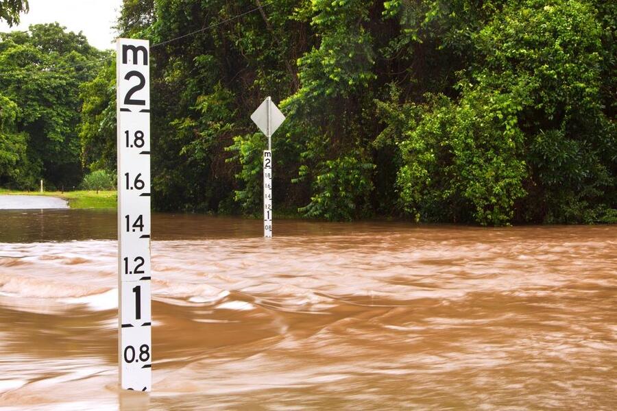
River flood:
When the water level rises beyond the river banks it termed as river flood.
Cause:
Excessive seasonal rain.
Persistent thunderstorms over the same area for extended periods.
Combined effect of rainfall and snowmelt.
Ice jam.
Coastal flood:
When the dry coastal areas submerged with seawater it’s called coastal flood.
Cause:
Combinational effects from sea tidal surges, high winds, and barometric pressure.
Tropical cyclones.
Higher-than-average tides.
Storm surge:
Sometimes Due to the astronomical tide the coastal areas submerged by an abnormal rise in water level, which is called as storm surge.
Cause:
Wind
Waves
Low atmospheric pressure
Inland flooding:
When the surged water level submerges the dry inland it is called the inland flooding.
Cause:
Paved roads and streets
Low-capacity drainage equipment
Dense buildings
Low amounts of green space
Flash flood:
Due to heavy rainfall this flood occurs within 6 hours, and often within 3 hours, of heavy rainfall.
Cause:
High rainfall rate
Long rainfall duration
Early warning system for flood:
To overcome the catastrophic effects from flood few urgent measures needs to be taken, such as support for money, food, medicine and construction materials for people from affected area. In the Digital Age, many countries have established disaster early-warning systems. Early warning systems are very crucial component of disaster risk management strategies.
A flash flood is different from other types of flood. It is of high velocity, containing much debris and occurring unexpectedly in minor basins with sloping terrain that results in massive destruction. The occurrence and development of flash floods is related to the intensity of rainfall, climate conditions, topographic features, human activities and the flood drainage conditions of the basins. The data of flash floods are usually available in very short time and it’s not systematic; thus, it is hard to use common methods to make hydrological predictions for flash-flood forecasts or warnings.
Key points for an integrated early warning system for flood system:
An early warning system for floods mainly consists of following four elements:
- Risk Knowledge.
- Monitoring and Warning Services.
- Disseminations and Communication.
- Response Capability.
Risk knowledge:
Assessments of risk require the systematic collection and analysis of data that would consider the nature of hazards that arise from processes such as urbanization, change in usage of rural land, environmental degradation and climate change.
Monitoring and warning services:
Warning services is basically sound alerts designed on the scientific basis for predicting and forecasting hazards to send warning to the system that operates 24 hours a day. The monitoring should be continuous to generate the parameters and contributing factors that is essential to generate accurate warnings in an accurate time.
Dissemination and communication:
Reachability of the warning is one of the most important factors. Simple alerts with useful information is required for proper understanding of warnings and responses in order to safeguard lives and resources.
Early warning communication systems are consists of the following components:
- Communication infrastructure hardware that must be reliable and robust, that can work efficiently during the natural disasters.
- Appropriate and effective interactions among medium through which the warning is supposed to spread, such as the scientific community, stakeholders, decision makers, the public, and the
Components used in integrated early warning for flood communication systems:
Tipping Bucket Rain Gauge:
It consists of a funnel and a small container which is fixed to a tipping lever. It collects a set amount of precipitation before the container tips. Accordingly it sends an electrical signal to a data transmitter.
Integrated Data Logging System:
It is a real-time monitoring station that consists of data logger, telemetry module, and power supply.
Mounting Hardware:
Data loggers can be mounted directly to the pier/abutment or to a pole, depending on the location and situation.
Radar Water Level Sensor:
Water level sensors using radar technology provides the gauging methods such as submersible pressure transducers, allowing the monitoring even in the locations which is hard to reach.
Telemetry:
Telemetry provides access to data in real time.
Live Data:
Project data is available 24/7 instantly through a cloud-based data center. Monitoring of the data can be viewed in real time.
Monitoring location:
While making the site selections few things should be taken into consideration such as, physical constraints of a site, the time to reach the location, legal and physical access to a site, and safety.
Communication devices:
Many communication tools are available for warning dissemination like Short Message Service (SMS), Email, Radio, TV, and web service.
Application:
It is a crucial part of natural disaster management and is being widely used in the flood prone areas such as localities in coastal regions and river banks etc.