Introduction
Security has always been a major global concern. It is meant to protect the country’s boundaries to stop illegal movement of in un-manned areas. It plays a key factor in maintaining peaceful civilization and prosperous economy. Any threat full intrusion can cause significant damage to a secured territory.
Securing a un-manned is challenging for many reasons, depending upon the exact size of the area that needs to be protected, weather condition and other aspects. The intrusion can be caused by a machine, human or an animal that causes the movement.
Geostationary satellite:
It is a remote sensing system, useful thing for border sensing over large areas. Almost 40 percent of the earth’s surface can be visible with a single geostationary satellite. Thus three such kinds of satellites, separated by 120 degrees of longitude, will provide coverage of the entire planet. Generally they are placed everywhere except the north and south geographic poles. These geostationary satellites can be accessed using a directional antenna, usually a small dish, aimed at the spot in the sky where the satellite appears to hover. An earthbound directional antenna can be aimed and then left in position without further manual management. With the use of highly directional antennas, any other interference, such as surface-based sources, other satellites, is not required that much.
But to monitor feed from the geostationary satellite specific software is required at the surfaced based monitoring station. This kind of software
being used at defense sector, such as government border security base camps or intelligence centers. It is required to deter terrorist infiltration and for anti-terrorist operations,
Satellite technology monitors people and goods at the border and also helps to keep them from trespassing. A combination of geostationary satellite and management software at the base station helps the immigrant infiltration at the border area.
Border security is ultimately about bringing together many different resources and technologies and making it available for a widely dispersed team. But geostationary satellite is the only technology in the world that can do the whole job from outside of this world with unsleeping vigilance,
satellites are guarding, from thousands of kilometers overhead.
Geostationary satellite plays many important roles in securing the border. The initial aspect is visibility. The earth observation geostationary satellite
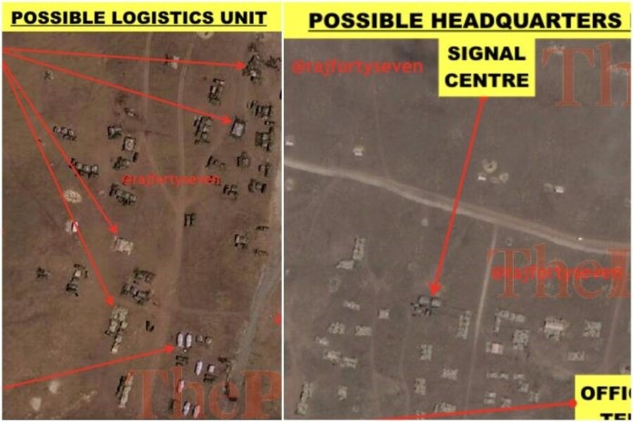
provides detailed images of those hot spots where the border crossings peak. These military reconnaissance geostationary satellites with local, state and Intelligence agencies are responsible for detection and prevention of terrorism, immigration and anti-smuggling programs. Here the Sensors are even able to penetrate cloud, detect human intrusions, vehicle intrusions, tunnel digging, cattle movements, chemical traces, nuclear radiations and identify objects inside perimeter & buildings.
The defense officials then capture still images as well as high-resolution video of the nation have disputed borders through these. These satellites
picks up new roads and tracks, massed vehicles, temporary settlements and even hot spots where the fences have been compromised by terrorists and migrants seeking access inside the Country.
Geostationary satellite is not just a like a sensors in the space but it also provide video and voice data, and helps to communicate with aircraft,
helicopters and other vehicles on border patrol to get proper communication about intrusion. It not only makes it possible for the widely scattered boarder area and forces to share crucial information and images, and but also helps the other surveillance devices to operate as a single unit. The surveillance radar units set up at borders are being automated with these geostationary satellites and the monitoring software enabled with AI. It is being used to detect and target moving threats over land. These satellites help the defense base monitoring stations to spot the tiny ultra
light aircrafts that is use for trafficking of illegal goods to the black market.
Arial vehicles including drones have changed the concept of war and play very crucial role in border patrolling. These drones are being able to stay afloat in the air for long time and can send real time videos. This helps to keep track of the border for the defense controlling agencies even from far
away .They are being managed via geostationary satellites through remote operating software.
Geostationary satellites and the satellite controlling technology help not only to detect the trespassers or illegal goods at the border but also keeping them from getting inside.
This feed in turn makes it easier to predict future immigration attempts and, through preparation, save lives.
Advanced sensor technologies coupled with sophisticated managing software and advanced algorithms, now allow routine retrievals of
important bio-geophysical/chemical variables used in long-term climate monitoring as well as operational resources management. Geostationary
(GEO) satellites, which were limited to monitor the atmospheric dynamics and weather in the past, are now able to make significant contributions to land monitoring.
The Geostationary (GEO) satellites also are being used for getting advance incoming missile warning so the defense system can take necessary actions accordingly. Geostationary satellite navigation constellations provide real time data about the missile invasion to the defense system with their precise location and local time. The geostationary (GEO) satellite helps in electronic warfare by including jamming and spoofing techniques to control the electromagnetic spectrum.
- Building a successful border surveillance solution with geostationary satellite consists of the following:
The technical configuration of the components like cameras, sensors, transmission modes, antenna, monitoring software. - The components themselves, especially the technology used in the components sensors, transmission modes, antenna, monitoring software.
- The human organization deployed in the security system.
- Reliable equipment suitable for defense system.
- Defense security integration expertise.
- Efficient training of security officers.
- Smart data processing for a better targeting of field interventions.
Different other types of technical equipments that can be monitored using for Geostationary (GEO) satellites:
Camera, thermal imagers, radars, drones, planes and helicopters, satellite surveillance, humans, vehicles, radio and cell data surveillance, mobile
surveillance equipments, specialized gear, biometrics, sound sensors, aerostats, unmanned aerial surveillance.
The application areas:
- Country International border.
- Disputed border.
- State border.